
Back in 2017, I went to the Intrepid Sea, Air & Space Museum in New York City to have a look at the exposition from DJI that showed the history of drones. The expo was titled, ‘Is The Sky The Limit’ and it exhibited how unmanned aircraft were used and developed over time.
Update, August 2026: These photos now anchor our complete history of drones, an evergreen guide that carries the exhibit’s story forward through DJI’s rise, the weaponization of consumer drones in Syria and Iraq, the FPV war over Ukraine, and the FCC’s DJI ban. It also corrects a few dates the museum placards got wrong. This photo essay stays up as the full-size gallery from my visit.
History of Drones: ‘Is The Sky The Limit?’ Intrepid exposition with DJI
The day that I went to the history of drones exposition, I took a lot of photos, that I never got around to editing and posting. However, to celebrate the new DroneXL website design that allows for photos to be displayed in a much larger format, I would like to share these images of drones throughout time with DroneXL readers today. I hope you’ll enjoy them.
Tip: This article is best viewed on a large display or laptop.


Is the sky the limit?
Over the last 75 years, drones have evolved from remote-controlled planes used for target practice into versatile and highly specialized aircraft. Drones -sometimes called remotely piloted vehicles, unmanned aerial systems, or unpiloted aerial vehicles-fly with no human on board. This capability, along with a combination of
onboard and remote control technologies, gives drones significant advantages over piloted aircraft.
Equipped with various degrees of autonomy, or self-control, drones perform long-duration, high-altitude surveillance. Others, armed with missiles, fly over and strike targets with a high degree of accuracy, without endangering the lives of pilots. Soldiers in the field carry suitcase-sized drones used to observe enemy positions. Drone helicopters deliver supplies to dangerous or hard-to-reach locations. Loaded with cameras and remote sensing equipment, some drones perform aerial surveys to analyze crop production and monitor the effects of climate change. Recreational drones have spawned the new sport of drone racing and given photographers and artists dynamic new ways of showing us the world.
As these aircraft fill the skies, they raise concerns about airspace, privacy and ethics in modern warfare. But these concerns are eclipsed by excitement for their potential: someday drones will explore Mars, serve as pilotless flying taxis, and deliver packages and groceries to our front doors.


Drones on Intrepid
A target drone about to launch from Intrepid in 1945 drew a
crowd of spectators from among the crew. Developed by the Radioplane Company during World War I (1939-1945), this drone and later versions became the most widely used target drones in U.S. military service. They set the stage for future
applications.


History of the Drone
Unmanned kites and balloons predate human flight by hundreds of years. The invention of gas-filled balloons in the 18th century made human flight feasible. The first practical winged aircraft was developed in the early 20th century. Daring aviators flew higher and farther, and flying machines soon revolutionized warfare.
The advantages of unmanned aircraft became evident: equipped with cameras, they would render a bird’s-eye view of the battlefield, and armed with bombs, they would attack enemy positions, all without risk to pilots. These capabilities came within reach after model airplane hobbyists developed radio control in the early 1940s. Early models of unmanned aircraft were flown as targets for anti-aircraft
gunnery practice. They were called “drones” because of the buzzing sound they made.
Guidance systems advanced and led to experiments using converted manned bombers for remotely guided bombing missions. By the 1950s, as Cold War tensions rose, jet-powered drones outfitted with advanced computers and high-resolution cameras supplemented piloted surveillance aircraft. Over the next decades, unmanned aerial systems became more versatile and sophisticated. By the 21st century, they were indispensable to the military.
Innovation and Imagination: The First Drones
Early inventors lacked flight experience but constructed pilotless aerial vehicles that observed the battlefield and even carried weapons. The earliest vehicles were in the form of balloons and kites. In December of 1903, the Wright brothers designed winged aircraft capable of carrying people. Soon after, this breakthrough was adapted for pilotless applications in warfare.


Sperry Aerial Torpedo, 1918
The modern-day cruise missile is a pilotless aircraft armed with explosives. It is designed for a one-way mission: to dive into a target. A precursor to the cruise missile was the Sperr Aerial Torpedo, a project funded by the U.S. Navy during World War I (1914-1918). The torpedo was successfully flown but not used in
combat.

Kettering Bug, 1918
The Bug was developed by the U.S. Army during World War I (1914-1918). It was designed to fly a predetermined course to a target. The wings detached, leaving the fuselage to drop like a bomb. Thousands were ordered into production, but the war ended before any were used in combat. Image courtesy of the National Museum of the United States Air Force

Eyes in the Sky: Imaging and Sensors
During the Cold War era (1947-1991), drones supported intelligence operations. New drones applied jet engine technology for speed and altitude. More advanced
computers improved preprogrammed flight paths, and more sophisticated cameras captured high-resolution images. Space-based satellites, also used to capture imagery, slowed the adoption of drones, but ultimately drones provided more precision. Satellites were locked into a set orbit, which limited their ability to capture an image at a specific time.
By the 1990s, drone systems rose to prominence in part because of their video capabilities, used in counterterrorism and counterinsurgency operations. Because they have more endurance than manned aircraft, drones loiter over key areas and provide soldiers on the ground with real-time intelligence.
Japanese Balloon Bombs
These completely autonomous devices were designed by the Japanese Empire during World War I. The balloons delivered high-explosive, incendiary bombs to western North America. Natural jet streams flowing east carried the balloons across the Pacific Ocean from Japan. The balloon bombs were intended to ignite large-scale forest fires, create fear among the civilian population and divert resources for defense.
The Japanese launched more than 9,000 armed balloons, but only 361 were found, scattered across 26 U.S. states, Canada and Mexico. Property damage from the balloon bombs was insignificant. However, in May 1945, an adult and five
children picnicking in rural Oregon were killed by one of these devices, which detonated after they touched it. These were the only fatalities in the continental United States due to enemy action during the war. The balloon bombs are considered the first intercontinental weapons in history.
Video courtesy of the U.S. Navy, from Critical Past

Fieseler Fi 103/V-1 “Buzz Bomb” and Republic- Ford JB-2 Loon

This German “vengeance” weapon from World War II used a relatively simple autopilot system to navigate from launch sites on the European mainland or from carrier-based aircraft to targets in England. Germany launched over 9,500 V-1s against England and another 2,448 against Belgium. After the war, the U.S. Navy
captured V-1s and used them to develop the JB-2 Loon, shown here during a test fire from USS Cusk (SSG-348). The JB-2 contributed to the development of more advanced unpiloted systems in the decades that followed.
Image courtesy of Bundesarchiv, Bild 146-1975-117-26/Lysiak/CC-BY-SA 3.0
and the U.S. Navy

SSM-N-8 Regulus I

The Regulus I was a remotely guided bomb conceived during World War Il and built in the early 1950s. It was powered by a turbojet engine and carried a 3,000-pound (1,400-kg) nuclear warhead. After a rocket-assisted takeoff, it flew at subsonic speeds and had a range of 500 miles (800 km). Regulus I was deployed from 1955 to 1964 on several aircraft carriers, heavy cruisers and submarines,
including the Museum’s Growler(SSG-577). The Regulus represents a bridge between the technology of World War I and the advancements of the Cold War era.
Collection of the Intrepid Sea, Air & Space Museum. P00.2013.01.591
Operation Anvil and Aphrodite

During World War II, the U.S. Army Air Force and U.S. Navy used older “war-weary” B-17 and B-24/PB4Y bombers as pilotless flying bombs. These modified aircraft were packed with explosives and sent on a one-way mission. The aircraft required full pilot control for takeoff, but once airborne, the pilots armed the onboard explosives and parachuted from the aircraft, which was then remotely guided to its target. Lt. Joseph Kennedy Jr., the eldest brother of President John F. Kennedy, participated in these operations. Tragically, on August 12, 1944, Kennedy’s plane exploded prematurely, killing him and his copilot, Lt. Wilford Willy.
Images courtesy of the U.S. Navy


U.S. Navy TDR-1
This assault drone, developed by the U.S. Navy, had limited success during World War I. The TDR-1 carried a torpedo or a 2,000-pound (907-kg) bomb and used a rudimentary television-based guidance system. It was controlled at a distance by a modified Grumman/ Eastern TBF/TBM Avenger aircraft. It flew a total of 46 missions and scored 18 successful hits during a campaign against Japanese
targets in the Solomon Islands. The project was canceled in 1944, but the TDR-1 paved the way for the next generation of guided missiles and drone technology.
Image courtesy of the U.S. Navy
Gyrodyne QH-50 Drone Anti-Submarine helicopter (DASH)

The DASH completed 43 years of continuous military service. Developed by the Gyrodyne Company in the late 1950s, the DASH served at sea on smaller U.S. Navy ships that were unable to carry piloted aircraft. It was a delivery platform for the Mark 57 nuclear depth bomb, which could neutralize several enemy submarines while U.S. ships remained a safe distance away. From January 1963 to
January 1971, the DASH was used for anti-submarine reconnaissance. It carried the Mark 44 torpedo, shown here, and the improved Mark 46 torpedo. Until May of
2006, the DASH was also flown as a target-towing aircraft by U.S. Navy and Army weapons test centers.
Rotor diameter: 20 feet (6.1 m)
Length: 12.9 feet (3.9 m)
Weight: 2,285 pounds (1,036 kg)
Speed: 92 miles per hour (148 kph)
Range: 82 miles (132 km)
Propulsion: Boeing T50-BO-8A turbine
Payload: Two Mk-44 or Mk-46 torpedoes
On loan from the Peter P. Papadakos Family Trust


Model Airplanes Evolve: Aerial Targets
After World War I (1914-1918), aviation technology blossomed. Airplanes flew faster, higher and farther than ever before. The technology inspired a new hobby and created an upsurge in model airplane enthusiasts. A proliferation of small companies developed miniature gasoline-powered engines and crude but imaginative control devices for models. World War I (1939-1945) ushered in a
technology transfer. These model airplanes became airborne target training drones.


Reginald Denny
During the 1930s, Denny pioneered large radio control models that reflected popular aircraft of the day. He eventually turned his hobby into a business. Image courtesy of the Righter Family Archives
Marilyn Monroe as a Radioplane Factory Worker

In 1944, Norma Jeane Mortenson, better known as Marilyn Monroe, assembled target drones at the Radioplane Company in Van Nuys, California, before becoming film star.
Crewman Readying a TDD Target Drone

A crewman readies a target drone for launch from USS Wyoming (AG-17) in 1945. Target drones provided more realistic training for the ship’s anti-aircraft gunners. The gunners fired real ammunition at the drone, a flying target. An onboard parachute recovery system retrieved targets that were not destroyed so that they could be used again. Image courtesy of the National Archives.
Recycled Targets

The F-16 Falcon, once the premier fighter aircraft for the U.S. Air Force, is now the QF-16 Aerial Target. Since World War Il, the U.S. Navy and Air Force have converted retired airplanes into drones and used them as targets in training and testing.
Military Drones
In modern military operations, drones take on diverse forms and a multitude of tasks. Large surveillance drones fly extended missions at high altitudes, and attack drones deliver missiles and laser-guided bombs. These large aircraft are “piloted” by crews thousands of miles of away. Compact surveillance drones, which fit into a backpack, are launched during battle and flown by a soldier with a game-like
controller. Drones between these extremes provide long-range intelligence, surveillance and reconnaissance, as well as immediate aerial battlefield perspectives.
Drones are cheaper than piloted aircraft and keep soldiers out of the line of fire. With these benefits, they will be adapted for more tasks. Drones will transport ammunition and fuel to dangerous terrain on a routine basis, evacuate
casualties, and act as communication relays. As their applications increase, so too will the ethical controversies of conducting warfare at a distance, the civilian casualties of remotely targeted airstrikes, and the psychological toll on military personnel who carry these strikes out.


Military Operations Today
The U.S. military classifies drones into five groups according to weight, operating altitude and airspeed.
Group I includes small drones weighing less than 20 pounds (9 kg), such as the RQ-11 Raven. They are carried by an individual soldier and potentially hand-launched. These drones provide battlefield intelligence, surveillance and reconnaissance for small units. Operators learn to fly them in just a few days.
Drones in groups Il and Ill are larger and capable of longer-duration missions. These drones, which include the RQ-7B Shadow and RQ-21 Blackjack, can generally handle additional tasks, such as laser targeting for weapons. Flying
them requires several months of specialized training.
Groups IV and V include larger drones that fly at higher altitudes. The MQ-1 Predator and RQ-4 Global Hawk, which are large enough to carry and fire weapons, fall into these groups. Operating these drones takes several years of
training.
Most military drone operations today focus on gathering information or deploying weapons. These vehicles will soon have additional capabilities, such as supply transport, medical evacuation or communication relay between units. Drones are also a force multiplier -another tool in the arsenal for commanders.


Military Drone Classifications

Boeing Insitu ScanEagle
Not all drones require a runway. The Boeing Insitu ScanEagle is launched from a catapult on land or on a ship. It was the first drone approved by the Federal Aviation Administration for commercial use beyond the operator’s line of sight.
Fishermen use the ScanEagle to locate schools of fish. Later adapted for military use, the ScanEagle played a key role in the rescue of Capt. Richard Phillips by U.S. Navy SEALs during the 2009 hijacking of Maersk Alabama by Somali pirates.
ScanEagle (2002-present)
Wingspan: 10.2 feet (3.1 m)
Length: 5.6 feet (1.7 m)
Weight: 39.7 pounds (18 kg)
Speed: 92 miles per hour (148 kph)
Flight Duration: 24 hours
Propulsion: Orbital two-cylinder gasoline
Payload: Cameras and sensors


Drone Recovery
Many larger drones require a runway in order to land. Some smaller drones make a controlled crash at a designated location. The ScanEagle uses a unique system called the Skyhook. Differential GPS guides the drone to a rope hanging from a pole on the ship. A hook on the ScanEagle’s wingtip catches on the rope as it flies past.


AeroVironment RQ-14 Dragon Eye
The Dragon Eye is a small reconnaissance drone developed by the Naval Research Laboratory and the Marine Corps Warfighting Laboratory. It has a simple rectangular wing and no tail, and it fits into a backpack. Weighing nearly six pounds (2.7 kg), it can be launched by hand or by using a common elastic cord. It has a high degree of durability and is easily repaired. While in flight, the Dragon Eye’s camera transmits a live image to the operator’s goggles, giving the operator a first-person view. It navigates using a GPS-based waypoint system and is used by the U.S. Marine Corps to scout urban areas.
RQ-14 Dragon Eye (2002-present)
Wingspan: 3.6 feet (1.1 m)
Length: 3 feet (0.9 m)
Weight: 5.9 pounds (2.7 kg)
Speed: 40 miles per hour (65 kph)
Flight Duration: One hour
Propulsion: Twin electric motors
Payload: Camera


On loan from the National Museum of the Marine Corps.
Transport by drone
The Israeli Cormorant, a large unmanned drone, transports supplies within combat zones and evacuates casualties from the front lines. While still in the relatively early stages of implementation, drones like the Cormorant have the potential to significantly change logistics in warfare.

Urban Aeronautics Cormorant
Transporting food, ammunition and fuel through contested or enemy territory is often a risky endeavor. Typically, getting supplies to the front lines requires a complex logistical chain from the home country to international bases.
The Israeli Cormorant, a large unmanned drone, transports supplies within combat zones and evacuates casualties from the front lines. The Cormorant is a compact vehicle with internal lift rotors. The rotors enable it to fly in areas obstructed by trees, buildings or people. Helicopters and drones with exposed rotors are unable to operate in these areas.

Unmanned Aerial Refueling
The Northrop Grumman X-47B was designed to launch and land on aircraft carriers and to conduct strike missions with very little human input from a remote control station. Despite a successful test program, including nearly flawless carrier operations, the military changed the aircraft’s mission to aerial refueling. It was renamed the MQ-25 Stingray and will be operational in the next decade. This shift from a tactical mission to a support mission is an effort to balance the use of drones with the interests of pilots, who strive to remain relevant as drones become more capable of replacing them.

Hunter Killers
The General Atomic MO-1 Predator entered service in 1995 as a surveillance platform. Armed versions were developed and deployed soon after the terrorist attacks of September 11, 2001. The Predator’s replacement, the General Atomics MO-9 Reaper, carries 15 times more ordnance, and its cruise speed is more than twice as fast.
Predator and Reaper Comparison
MO-1 Predator (1995-present)
Wingspan: 55.3 feet (16.8 m)
Length: 27 feet (8 2 m)
Weight: 2,250 pounds (1,020 kg)
Speed: 135 miles per hour (217 kph)
Flight Duration: 24 hours
Propulsion: Rotax 914F turbocharged gasoline
Payload: Cameras, sensors, and two hardpoints for a combination of AGM-114 Hellfire, AIM-92 Stinger or AGM-176 Griffin air-to-surface missiles
MQ-9 Reaper (2007-present)
Wingspan: 65.5 feet (20 m)
Length: 36 feet (11 m)
Weight: 10,494 pounds (4,760 kg)
Speed: 300 miles per hour (482 kph)
Flight Duration: 14 hours
Propulsion: Honeywell TPE331-10 turboprop
Payload: Cameras, sensors, and seven hardpoints for a combination of AGM-114 Hellfire. AIM-92 Stinger or GBU-12 Paveway Il and GBU-38 Joint Direct Attack Ammunition


Autonomous Transport Helicopters
The Kaman K-MAX drone was formerly a logging helicopter that lifted oversized cut timber. It delivered over 2,250 tons of cargo to marines in Afghanistan from 2011 to 2014. On loan from Lockheed Martin and Kaman

Ethics of Drone Strikes

Between 2009 and 2016, the U.S. government carried out 526 strikes, mostly by drones, resulting in approximately 3,000 deaths.*
Whether drones are an appropriate method of carrying out lethal force is an ongoing debate. Advocates for drone use argue that drones take out important targets precisely and effectively. They also claim that drones cause fewer civilian casualties than other forms of strikes. Opponents argue that fighting an unmanned foe has created more animosity toward the west and that drone strikes break the traditions of just warfare. *From Summary of Information regarding U.S. Counterterrorism Strikes outside Areas of Active Hostilities, ODNI News Release, December 31, 2016. (Non-governmental organizations estimate these numbers to be somewhat higher.)
Drones, Drones, Everywhere!
Military advances paved the way for a new generation of inexpensive and sophisticated unmanned aerial systems. Lightweight, portable and easy to operate, drones of the 21st century have been adapted for civilian, scientific and commercial use.
Drones equipped with specialized cameras, sensors and instruments have revolutionized research in climate, agriculture and wildlife conservation. They scan ancient ruins and allow archaeologists to see patterns of development. Drones inspect bridges, oil rigs and other critical infrastructure from vantage points too dangerous for piloted aircraft. And they deliver humanitarian aid to areas
rendered inaccessible by natural disasters or war.
Police and fire departments are experimenting with drone patrols. Photographers, filmmakers and artists are gaining new perspectives on the world. Eager hobbyists have a new way to fulfill their fantasies of flight, and goggle-wearing drone racers create gaming worlds that bridge real life and virtual reality. And very soon drones may deliver packages to our doors cheaply and efficiently.
These capabilities come with concerns over access to limited airspace and invasions of privacy by prying eyes in the sky. Regulators are struggling to keep up with the explosive growth of this versatile technology.
Drones, Drones, Everywhere! is sponsored by DJI.


Aerial Perspective
An aerial perspective is an asset to security and public safety. In the United States, border protection, municipal police and fire departments and other agencies use
unpiloted vehicles as their eyes in the sky.

Police Drone
The Draganflyer X6 has an aerial camera. Law enforcement officials use this drone to assist officers in the field. The Mesa County Sheriff’s Office in Colorado was one of the first agencies to use drones, introducing them In 2009.

Firemen’s helper
The Fire Department of New York, the largest municipal fire department in the United States, recently deployed a drone capable of transmitting a live video image. The bird’s-eye view improves the situational awareness of on-scene commanders and fire chiefs, helping them fight fires more effectively and save more lives. The drone also ventures into dangerous places to help investigators determine the origin of the fire. Image courtesy of the Fire Department of New York.
Consumer Drones
The DJI Phantom 3 Pro has simple user interfaces and some onboard autonomy, or autopilot capabilities, making it friendly for novices interested in aerial photography. This drone was used to explore the Son Doöng Cave in central Vietnam, one of the largest cave systems in the world.

A New Tool for Photography and Videography
Photographers and filmmakers, including Hollywood production studios, use drones to shift visual perspectives and evoke a unique sense of space and landscape.
Recreational imaging has raised privacy concerns, and use of drones for these purposes has been limited. Many countries are struggling to define regulations and rules.

Exploring from new angles
The new generation of camera-carrying drones are inexpensive yet very sophisticated. Lightweight, portable and easy to operate, drones of the 21st
century have been adapted for many civilian applications Amateur and professional photographers and filmmakers use drones to shift visual perspectives and evoke a unique sense of space and landscape In this video, filmmakers used drones to document the Citadelle Laferrière, a World Heritage site in Haiti, from perspectives never before possible.

Agriculture
Drones can carry standard cameras and advanced multispectral imaging systems. These tools help farmers monitor plant health, manage fields, and assess problems
such as invasive weeds and weather damage. Farmers face more challenges due to worldwide climate change, which has brought unexpected flooding in some areas and persistent drought in others. Small, unpiloted vehicles are far less expensive than conventional aircraft and allow farmers to respond to problems more quickly.

Mapping Farms: Seeing in Infrared
Images taken by drones help farmers apply fertilizers and pesticides more
effectively, reducing waste and pollution. Drones compare visible images
and infrared radiation images. Special sensors in the drone’s camera pick up subtle
differences in crop rows not apparent to the naked eye. These subtle differences appear in bright yellows, oranges, red, and greens.

Growing Potential
Canada has used drone technology in agriculture for several years, as have nations in South America, Asia, and Europe. Farmers in Japan alone employ over 10.000 unmanned aerial vehicles to improve agriculture. Corporate investors in the United States project that agricultural drones will make up almost 80 percent of the commercial drone market in the future and will generate $82 billion worth of economic growth in the next 10 years.

Medical Supply Delivery
Most of the world’s population has no direct access to lifesaving medical supplies. More than 800 million people in the world have limited access to basic health services. New types of drones and management systems on the ground will deliver urgently needed medical supplies to remote communities.


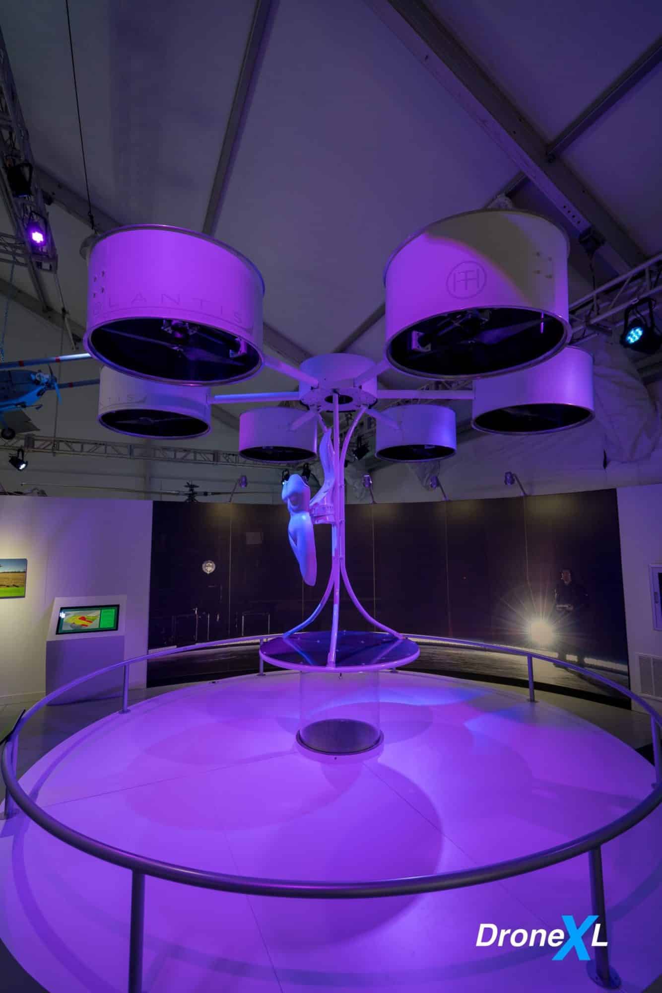
The Grandest of Entrances
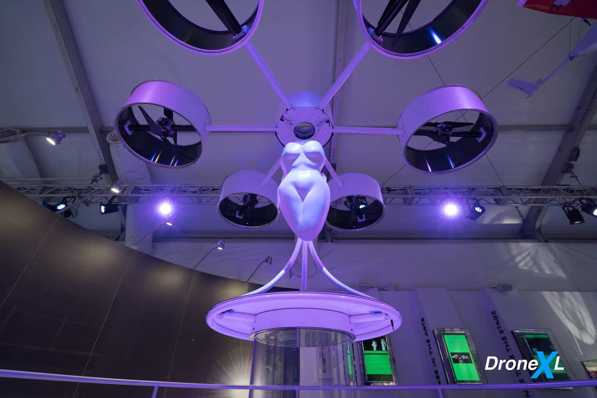
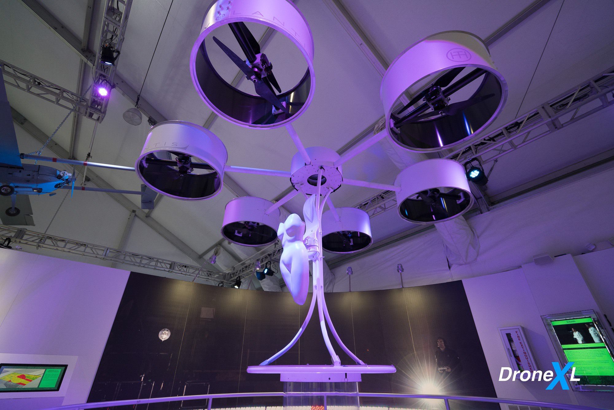
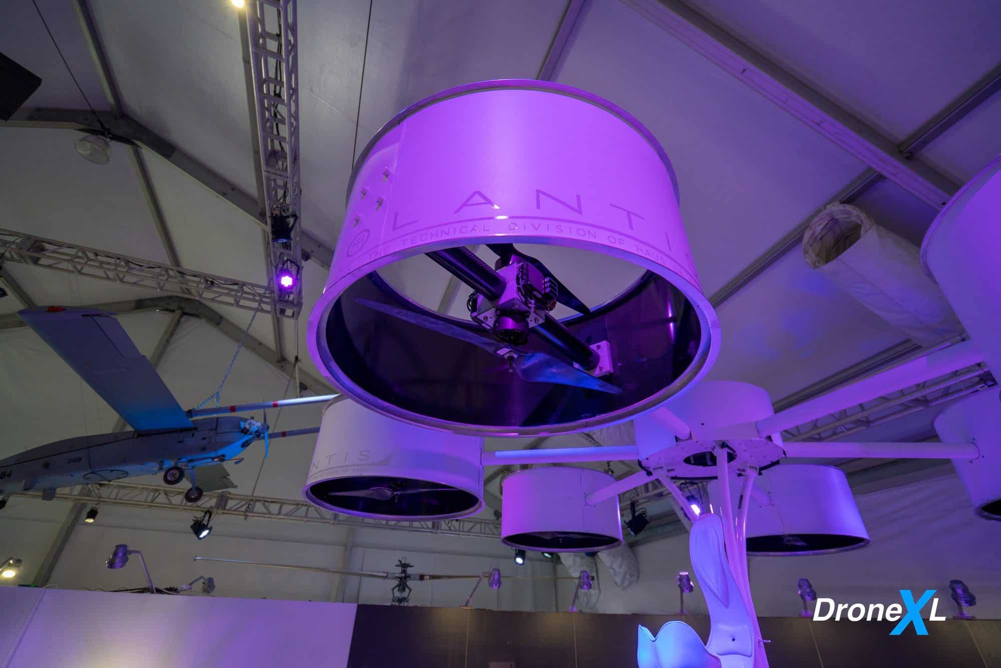
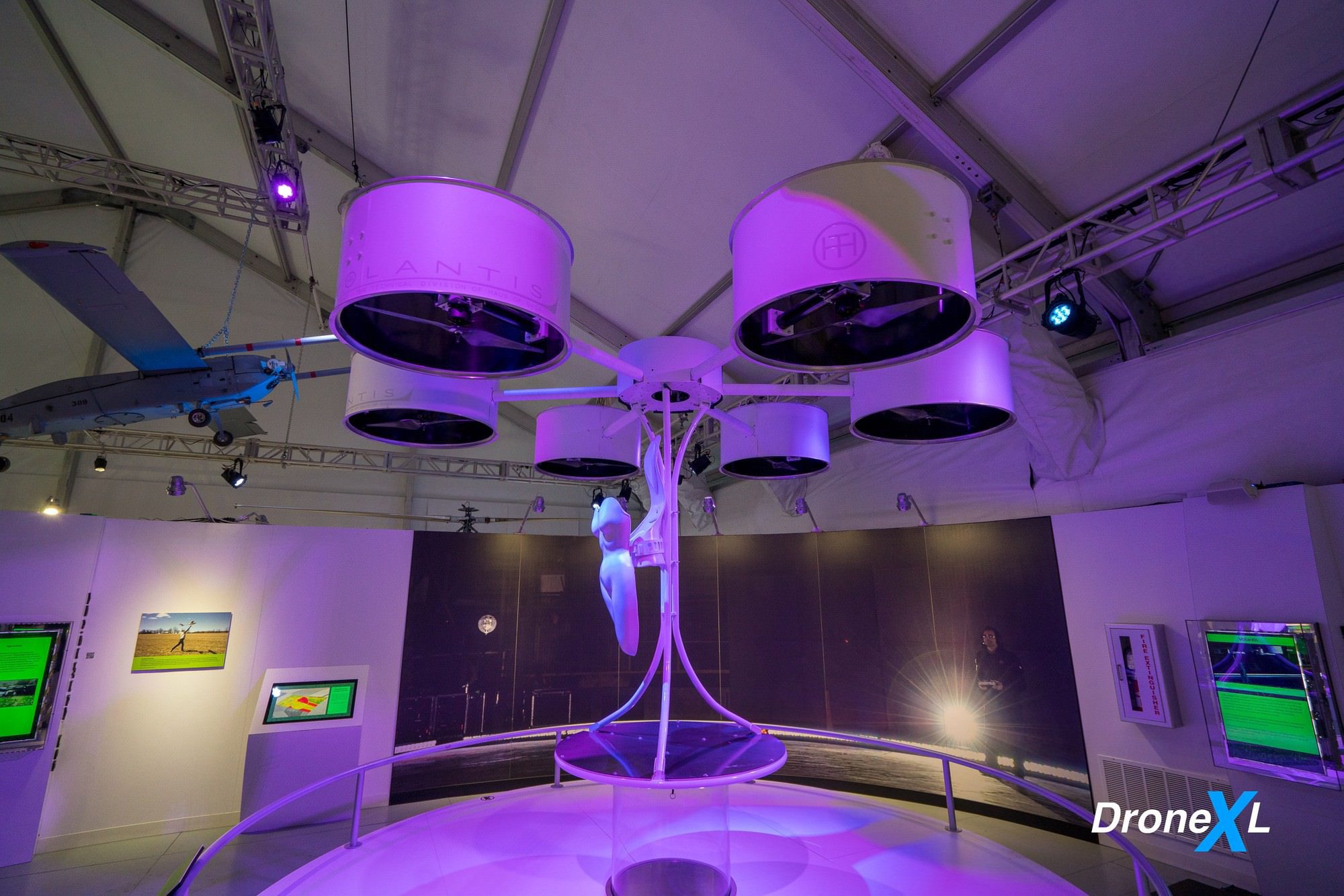
Lady Gaga’s entrance at her 2013 album release event represented a pioneering moment for drones and the arts. In the vehicle, the passenger has no ability to control the craft, possibly making it the first aircraft capable of carrying a person while piloted exclusively by a remote operator. Battery-powered electric motors drive propellers housed in six shrouds, which are mounted on booms in a hexagonal pattern around a central column. The vehicle has the ability to hover and
maneuver three feet above the ground. This “flying dress” was designed by Lady Gaga in collaboration with TechHaus, the technology development division of Haus of Gaga, and Studio XO. On loan from Haus of Gaga
Humanitarian Applications
New ventures all over the world are helping people harness the life-saving potential of drones. In developing countries, communities are learning to use drones to reduce disaster risk and improve post-disaster response and recovery. Once
trained and equipped to use drones, local populations will fly their own missions to provide aid for people in need. Though the success of this training is currently difficult to gauge, the initiatives show promise.

Sparked
The whimsical drones of Cirque du Soleil’s Sparked fly in an autonomous formation suitable for tight quarters. Known for extravagant productions with aerial acrobatics and lavish costumes, Cirque du Soleil used drones in this film to bring
lampshades to life. The lampshade drone on display in this exhibition appears in many of the scenes. Cirque du Soleil also produced the Broadway musical Paramour, which premiered on May 25, 2016, at the Lyric Theatre in New
York City. Paramour uses the same drone concepts and technologies that were developed for Sparked.


Delivery by Drone
Flying autonomously, a drone can deliver a package from a warehouse straight to your doorstep. By reducing the need for trucks, these all-electric delivery vehicles will reduce the carbon footprint for package delivery. Transporting goods directly to residential and office locations is called last-mile transport. Small-scale testing of last-mile transport by drones has already begun in the United Kingdom, Switzerland and rural parts of China.
Large-scale drone delivery will require operating many drones simultaneously. Current air traffic control methods cannot scale to this number of unmanned vehicles. Delivery by drones will require a new solution for air traffic control -another instance of the pace of technological innovation challenging existing infrastructure.

Drones at Your Doorstep
Amazon Prime Air, currently in development, will deliver packages weighing up to five pounds directly to homes and businesses.
Amazon Prime Air (2016-present)
Width: 32 inches (.81 m)
Length: 32 inches (.81 m)
Weight: 25 pounds (11.33 kg)
Speed: 40 miles per hour (64.4 kph)
Flight Duration: 30 minutes
Propulsion: Electric motor


Network of Drones

Racing drones or FPV drones

Coyote Drone
The Coyote goes where no person or machine has gone before – the center of a storm. Data collected at this low altitude gives forecasters a better image of a storm’s intensity and direction of travel.
Coyote
(2016-present)
Wingspan: 4.8 feet (1.5 m)
Length: 2.98 feet (0.9 m)
Weight: 14 pounds (6.4 kg)
Speed: 85+ miles per hour (136.7 kph)
Flight Duration: 1.5 hours
Propulsion: Electric motor
Payload: Sensors

Tracking Hurricanes
The National Oceanic and Atmospheric Administration (NOAA) deploys manned aircraft to monitor and track developing tropical storms in the Atlantic Ocean. Much of the valuable data about the storms is at lower altitudes, but flying below 3,000 feet is too dangerous for manned aircraft.
The Coyote, dropped from a manned aircraft, flies into the dangerous low-altitude zones of a storm to collect crucial data. It is equipped with temperature, pressure and wind sensors. Since 2016, NOAA has used this data to create more accurate models of projected storm paths and further our understanding of hurricane development.


Air Taxis


Terrafugia TF-X
Private transportation of the future may look like the Terrafugia TF-X. This autonomous flying machine will provide fast, affordable and environmentally friendly short-distance transport for commuters. Able to travel at 200 miles per hour (320 kph), the TF-X will take off and land vertically from a level clearing of at least 100 feet (30 m) in diameter. Flying the vehicle will require substantially less training time than a traditional pilot’s license or sport pilot certificate. Driving the TF-X will only require a standard U.S. driver’s license.


Living with Personal Drones
Traveling in autonomous air vehicles may one day be as common as the automobile is today. This rendering depicts urban apartments with balconies that double as drone landing pads. In this vision of the future, drones function like a ride-sharing service.


REGULUS I MISSILE
Soon after the end of World War I (1939-1945), the U.S. Naw looked toward
submarines as mobile, covert platforms for launching nuclear missiles. Designed by the Chance Vought Aircraft Company, the Regulus I missile was the Navy’s first operational cruise missile.
A jet engine propelled Regulus I missiles. They could carry conventional or nuclear
warheads. The missile’s most powerful warhead, the W27, had a yield of two megatons, more than 100 times the explosive force of World War Il nuclear bombs. The missile was guided to its target or to a second control source using a radar control system known as TROUNCE.
Five submarines, including Growler, carried Regulus missiles. Together, these boats
conducted about 40 deterrent patrols in the western Pacific Ocean from 1959 to 1964.
The missile also was deployed on aircraft carriers and heavy cruisers. Regulus missiles were removed from service in 1964, replaced by Polaris ballistic missiles in newer George Washington-class submarines. Polaris missiles could be launched from a submerged submarine because they used solid-fuel propellant. In contrast, jet-powered cruise missiles such as Regulus had to be launched from the surface. Polaris missiles, and their submarines, had distinct advantages in terms of increased stealth, speed, payload, range and guidance.
AIAA sponsorship
AlAA is the proud sponsor of Drones: Is the Sky the Limit? and supporter of the
Center for the Study of the Drone at Bard College’s In the News interactive education station at the Intrepid Sea, Air & Space Museum.


Get your Part 107 Certificate
Pass the test and take to the skies with the Pilot Institute. We have helped thousands of people become airplane and commercial drone pilots. Our courses are designed by industry experts to help you pass FAA tests and achieve your dreams.

FTC: DroneXL.co uses affiliate links that generate income.* We do not sell, share, rent out or spam your email, ever. Our email goes out on weekdays around 5:30 p.m.
Stay in touch!
If you’d like to stay up to date with all the latest drone news, scoops, rumors, and reviews follow us on Twitter, Facebook, YouTube, Instagram, or… Subscribe to our Daily Drone News email.*


