British government green lights construction drone super highway

Check out the Best Deals on Amazon for DJI Drones today!
The UK government has approved a plan to link several UK cities through a drone super highway. The idea is that companies can use several fixed flight routes to develop and test new services. The drones can fly safely out of the pilot’s sight.
Drone super highway
The idea of the network of corridors was put forward by the British software company Altitude Angel, which develops software that allows drones to be tracked and controlled, taking into account different air traffic and unexpected circumstances. Such unmanned traffic management (UTM) software forms the foundation for a future in which drones can fly around anywhere and at any time to perform all kinds of tasks, such as transporting packages or carrying out inspections.
The only problem is that UTM cannot simply be rolled out nationally, the situation is still too complex and too many stakeholders are involved. As a prelude to a nationwide UTM system, Project Skyway was proposed in April this year, consisting of a number of airborne corridors connecting the British cities of Reading, Oxford, Milton Keynes, Cambridge, Coventry, and Rugby. In total, this concerns 166 miles of super highway for drones.
Green light
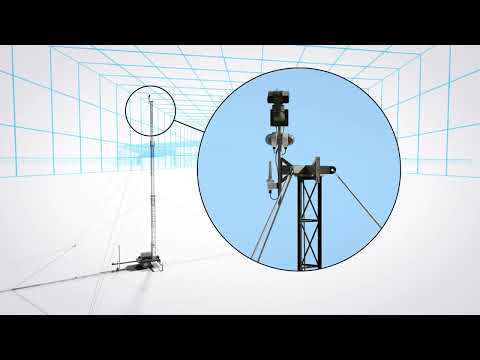
The British government sees merit in the plans and has now given the green light for the roll-out of Project Skyway. The government is also making 14 million euros available. Altitude Angel will oversee the project together with a consortium of companies and startups. Consortium partner BT Group will provide the 4G and 5G connectivity that the drones can use to receive control commands and transmit data. To this end, 29 special transmission towers will be built along the routes.
A ground-based network of detect and avoid (DAA) sensors is being created to prevent drones from coming dangerously close to manned air traffic. This creates a very accurate and up-to-date digital representation of all activities in the airspace. In this way, drone flight paths can be adjusted at any time if necessary to avoid airproxes or even collisions.
According to the initiators, Project Skyway enables developers of drones and drone applications to easily develop new services. To do this, they only need to create a software link with the system. This is not only accessible, it also saves weight on board the drone. The system should be operational from mid-2024.
Airspace not locked
According to a spokesperson for Altitude Angel, drone pilots in the Open Category can also continue to fly in the corridors. “The corridors don’t exclude air users – it’s all about inclusion, not exclusion. Drone pilots flying VLOS can use the airspace in and around the corridor. The airspace will not be closed or restricted.”
Let us know in the comments below, what you think about the UK government green lighting the drone super highway project.
Discover more from DroneXL.co
Subscribe to get the latest posts sent to your email.
Check out our Classic Line of T-Shirts, Polos, Hoodies and more in our new store today!

MAKE YOUR VOICE HEARD
Proposed legislation threatens your ability to use drones for fun, work, and safety. The Drone Advocacy Alliance is fighting to ensure your voice is heard in these critical policy discussions.Join us and tell your elected officials to protect your right to fly.
Get your Part 107 Certificate
Pass the Part 107 test and take to the skies with the Pilot Institute. We have helped thousands of people become airplane and commercial drone pilots. Our courses are designed by industry experts to help you pass FAA tests and achieve your dreams.

Copyright © DroneXL.co 2026. All rights reserved. The content, images, and intellectual property on this website are protected by copyright law. Reproduction or distribution of any material without prior written permission from DroneXL.co is strictly prohibited. For permissions and inquiries, please contact us first. DroneXL.co is a proud partner of the Drone Advocacy Alliance. Be sure to check out DroneXL's sister site, EVXL.co, for all the latest news on electric vehicles.
FTC: DroneXL.co is an Amazon Associate and uses affiliate links that can generate income from qualifying purchases. We do not sell, share, rent out, or spam your email.


