National Geographic team surveyed Mount Everest with a drone! [video]

Check out the Best Deals on Amazon for DJI Drones today!
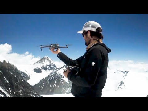
A team from National Geographic surveyed Mount Everest with a drone at 28,300 feet putting the unmanned aircraft in uncharted territory.
Surveying Mount Everest with a drone!
National Geographic is working on a documentary titled ‘Lost on Everest‘ which follows the 1924 expedition of George Leigh Mallory and Andrew ‘Sandy’ Irvine.
Mallory’s remains have been found in 1999, but Irvine’s body is still missing. It remains a mystery as to whether the team actually reached the summit before their unfortunate deaths. If they did, it would have been long before Edmund Hillary and Tenzing Norgay reach the top of Mount Everest in 1953.

![National Geographic Team Surveyed Mount Everest With A Drone! [Video] 1](https://u.djicdn.com/uploads/ad_image_file/file/4254/728x90-a_US_CA.jpg "National Geographic Team Surveyed Mount Everest With A Drone! [Video] 3")
Mark Synnott and Renan Ozturk from National Geographic renewed the search for Irvine’s body and brought with them a DJI Mavic 2 to survey the terrain. With the drone, the team was able to capture sweeping landscape views and close-up photos of key areas of Mount Everest, according to CNET.
![National Geographic Team Surveyed Mount Everest With A Drone! [Video] 2](https://dronexl.co/wp-content/uploads/2020/07/National-Geographic-team-surveyed-Mount-Everest-with-a-drone-3.jpg.webp)
They flew the drone as high as 28,300 feet or 8,625 meters, just shy of the summit of Mount Everest which is at 29,000 feet or 8,840 meters, flying the Mavic 2 into ‘uncharted territory.’

Stay in touch!
If you’d like to stay up to date with all the latest drone news, scoops, rumors, and reviews, then follow us on Twitter, Facebook, YouTube, Instagram or…
Subscribe to our Daily Drone News email.*
Submit tips If you have information or tips that you would like to share with us, feel free to submit them here. Support DroneXL.co: You can support DroneXL.co by using these links when you make your next drone purchase: Adorama, Amazon, B&H, BestBuy, eBay, DJI, Parrot, and Yuneec. We make a small commission when you do so at no additional expense to you. Thank you for helping DroneXL grow! FTC: DroneXL.co uses affiliate links that generate income.
* We do not sell, share, rent out or spam your email, ever. Our email goes out on weekdays around 5:30 p.m.
Photos courtesy of National Geographic
Discover more from DroneXL.co
Subscribe to get the latest posts sent to your email.
Check out our Classic Line of T-Shirts, Polos, Hoodies and more in our new store today!

MAKE YOUR VOICE HEARD
Proposed legislation threatens your ability to use drones for fun, work, and safety. The Drone Advocacy Alliance is fighting to ensure your voice is heard in these critical policy discussions.Join us and tell your elected officials to protect your right to fly.
Get your Part 107 Certificate
Pass the Part 107 test and take to the skies with the Pilot Institute. We have helped thousands of people become airplane and commercial drone pilots. Our courses are designed by industry experts to help you pass FAA tests and achieve your dreams.

Copyright © DroneXL.co 2026. All rights reserved. The content, images, and intellectual property on this website are protected by copyright law. Reproduction or distribution of any material without prior written permission from DroneXL.co is strictly prohibited. For permissions and inquiries, please contact us first. DroneXL.co is a proud partner of the Drone Advocacy Alliance. Be sure to check out DroneXL's sister site, EVXL.co, for all the latest news on electric vehicles.
FTC: DroneXL.co is an Amazon Associate and uses affiliate links that can generate income from qualifying purchases. We do not sell, share, rent out, or spam your email.