
Purdue University associate professor of computer science Aniket Bera posted a 44-second video on LinkedIn on Friday evening, October 23, of an autonomous drone following a person through a forest with no GPS and no prior map. His post says his IDEAS Lab “developed every layer of this autonomous drone from scratch.”
Two reposts of the clip on X passed 1.7 million views combined by Monday. Frame by frame, the video’s own telemetry overlay labels the drone’s motion planner as SUPER and its altitude estimate as FAST-LIO. Both are open-source packages from the University of Hong Kong, and the video doesn’t say whether the lab modified them.
SUPER and FAST-LIO Come From the University of Hong Kong’s MaRS Lab
SUPER is the motion planner that Fu Zhang’s MaRS Lab at the University of Hong Kong published in Science Robotics on January 29, 2025, with its code under the LGPL-3.0 license. FAST-LIO, the label on the altitude trace, is the same lab’s LiDAR-inertial odometry package, released under GPL-2.0.
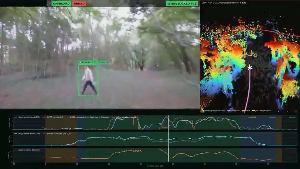
In Bera’s video, the LiDAR map legend also reads “SUPER cmd,” and the mode bands on the charts are Stabilized, Position and Offboard, the standard flight modes of the open-source PX4 autopilot. HKU reported SUPER flying a quadcopter with a 280 mm wheelbase through unknown environments at more than 20 meters per second (about 45 mph). FAST-LIO has about 5,300 stars on GitHub.
Kevin Biju Mathew, a Purdue graduate student researcher, answered two technical questions in the post’s comments. Localization uses LiDAR-inertial odometry, he wrote, and a “ROG map” turns each scan into a live 3D occupancy grid for the planner. ROG-Map is a third MaRS Lab package, presented at IROS 2024, and it ships inside the SUPER repository. Bera’s post lists “visual-inertial odometry” in the drone’s pipeline. Mathew’s answer and the FAST-LIO label point to LiDAR-inertial odometry instead.
The post does not mention the University of Hong Kong or the MaRS Lab. As of Monday, the IDEAS Lab’s publications page lists no paper on the forest demo, and DroneXL found none on arXiv.
HKU Publishes SUPER’s Airframe Files Too
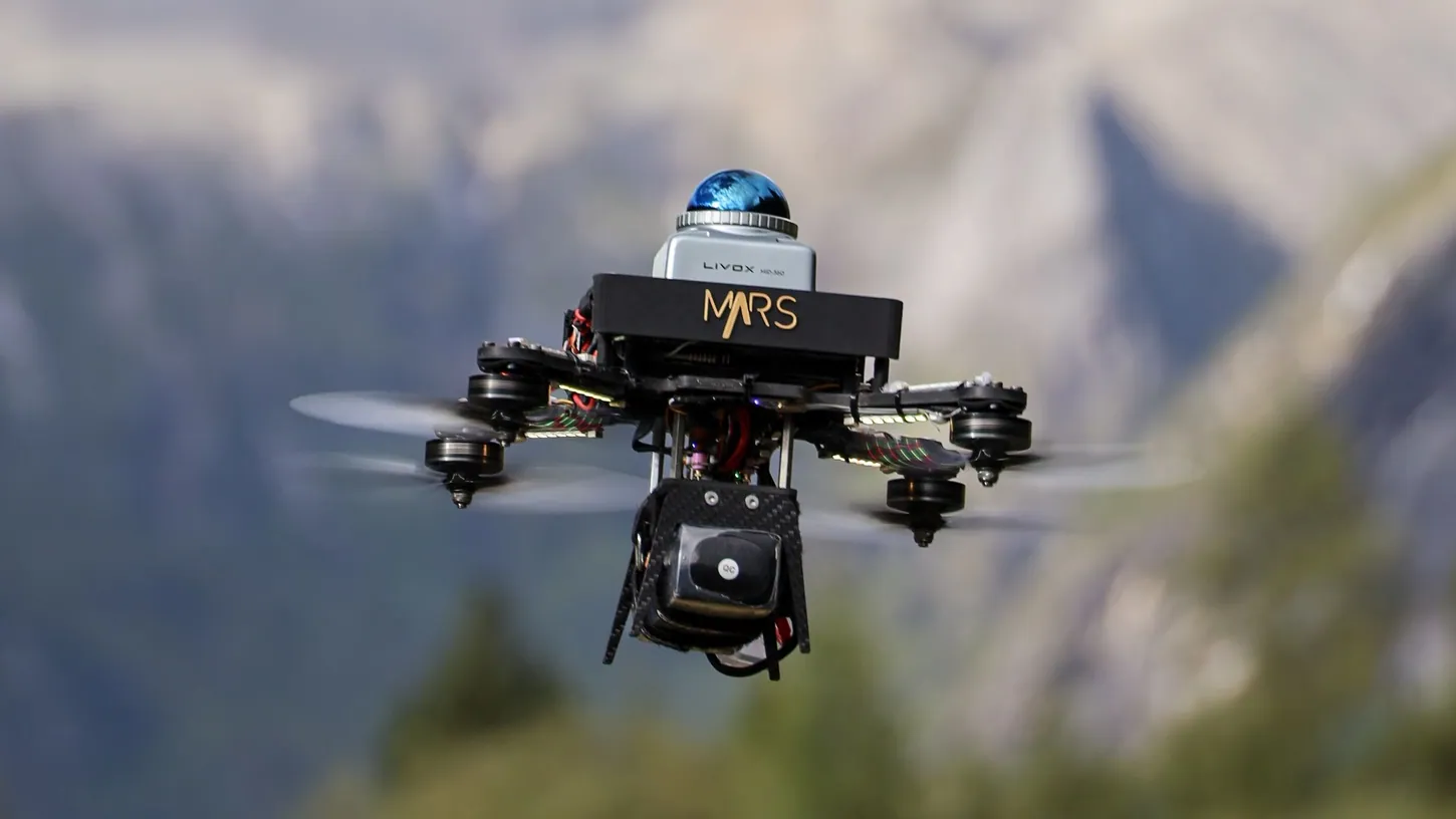
Bera’s post credits his lab with the CAD design and the 3D-printed carbon fiber airframes, and HKU released a kit of that kind for SUPER on March 9, 2025: SolidWorks assemblies, STEP files for 3D printing and carbon fiber cutting, and a full parts list under the MIT license.
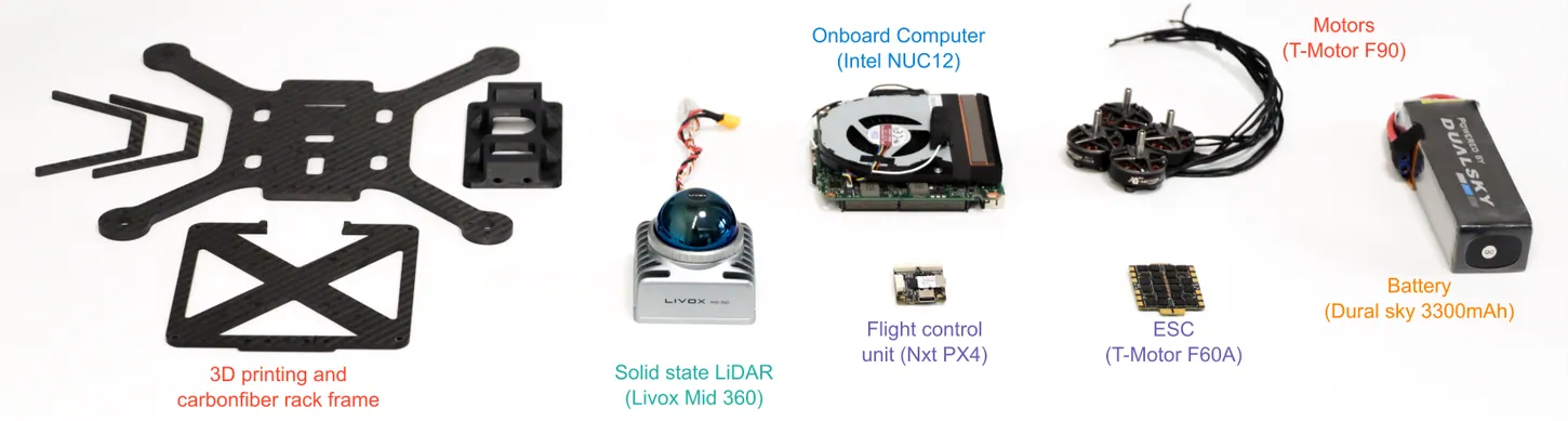
The SUPER-Hardware bill of materials pairs a Livox Mid-360 LiDAR, from the DJI spinoff that just launched a cheaper Mid-360L, with an Intel NUC 12 computer and an NxtPX4 flight controller. HKU says SUPER has been deployed for object tracking by day and at night. The released code is the planner, mapping and a simulator, not a person detector. Purdue’s video shows the camera feed, the LiDAR map and the charts, and never the airframe itself.
Bera’s Clip Shows a Jogging-Pace Follow at About 7 mph
In Offboard mode, the drone’s speed trace tops out near 3 meters per second, about 7 mph. It holds roughly 6.5 feet (2 meters) off the ground and 16 to 33 feet (5 to 10 meters) behind the person it follows, whom the overlay labels “walker.”
The 44 seconds join at least two armed sessions, because the chart’s seconds-since-arm axis restarts between them. Asked how the system handles the runner disappearing behind trees, Bera replied that a prediction module estimates the person’s path when they vanish or the tracking gets noisy.
For scale, the University of Zurich drone DroneXL covered in 2021 flew through dense forest at 25 mph. NYU’s NOVA system reported following a target through forest trails at more than 31 mph (50 km/h) using only a stereo camera and an IMU. On the consumer side, DC Rainmaker ran a DJI Neo 2’s tracking down tight forest trails in his gauntlet test.
The reposts added their own claims. Sadao Tokuyama’s Japanese-language post, at about 780,000 views, noted that it was a research demo whose real-world performance and safety still needed checking. Praveen Kumar Verma’s English rewrite, past 1 million views, promised “massive implications for next-gen search & rescue.” Bera’s post says nothing about search and rescue.
Bera’s Lab Holds a $1.5 Million Army Grant for GPS-Free Robots
Purdue has announced Army funding for Bera’s GPS-free robotics work. On November 26, 2025, the university said the Army Research Laboratory (DEVCOM ARL) had awarded his lab a five-year, $1.5 million agreement. It covers air and ground robots that map and navigate hostile terrain without GPS, using drones as scouts.
Bera’s LinkedIn post does not say what paid for the forest flights. Purdue’s announcement places that work in the university’s Hicks Robotics and Autonomy Testbed, part of a broader Purdue push into drone autonomy.
DroneXL’s Take
Building on SUPER, FAST-LIO and ROG-Map is the smart move, and I’d tell any lab to do the same. Tracking a person and predicting where they went behind a tree is real work, and if that’s what Purdue wrote, it deserves a paper.
“Every layer from scratch” is a different claim. The lab’s own charts carry the names of two Hong Kong packages, SUPER and FAST-LIO, and its grad student named a third. SUPER’s source files ask anyone who uses the code to cite the MaRS Lab’s publications, and Bera’s post doesn’t name the lab. In a field that runs on citations, I don’t think that’s a small omission. Put the MaRS Lab’s name on the video.
Sources: Aniket Bera on LinkedIn, Sadao Tokuyama on X, Praveen Kumar Verma on X, hku-mars/SUPER, hku-mars/SUPER-Hardware, hku-mars/FAST_LIO, Science Robotics, HKU Mechanical Engineering, Purdue Computer Science, IDEAS Lab publications, NOVA on arXiv
DroneXL uses automated tools to support research and source retrieval. All reporting and editorial perspectives are by Haye Kesteloo. Read our editorial standards.


